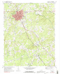
1969 Map of Siler City
USGS Topo · Published 1992About this map
Siler City stands as a primary hub of Chatham County in the late 1960s, its urban grid and industrial features centered around the Southern railway line. This survey captures a moment of mid-century development, where the city's growth is evidenced by institutions like Jordan-Matthews High Sch and a local Drive-in Theater. Beyond the city limits, the landscape transitions into a series of smaller rural communities and historic church sites that define the region's social geography. To the south, the village of Mt Vernon Springs sits near Welch Branch, while settlements like Bonlee and Edwards Hill anchor the bottom of the quadrangle. The agricultural and forested terrain is deeply etched by a network of waterways including Loves Creek, Tick Creek, and the Rocky River. Researchers will find significant genealogical interest in the numerous rural congregations, such as Gum Grove Ch and Palmers Chapel, which appear alongside an Old Railroad Grade that traces the area's earlier transport history.
Find a feature on this map
40 named features on this map. Tap any name to fly to it.
Don’t see what you’re looking for? This feature index may not catch every label — zoom into the map to look around manually.
Map Details
Editions of this 1969 Siler City Map
2 editions found
Other maps of this area

1953 · Raleigh
USGS Topo · 1:250,000

1954 · Raleigh
USGS Topo · 1:250,000

1968 · Coleridge
USGS Topo · 1:24,000

1968 · Bennett
USGS Topo · 1:24,000

1969 · Siler City
USGS Topo · 1:24,000

1970 · Goldston
USGS Topo · 1:24,000

1970 · Bear Creek
USGS Topo · 1:24,000

1970 · Siler City NE
USGS Topo · 1:24,000

1974 · Silk Hope
USGS Topo · 1:24,000

1974 · Crutchfield Crossroads
USGS Topo · 1:24,000