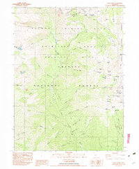
1982 Map of Siligo Peak
USGS Topo · Published 1982About this map
The high backcountry of the Trinity Alps Primitive Area is documented here as it appeared in the early 1980s, before its redesignation as a formal wilderness. The landscape is defined by its glacial hydrology and mining history, with numerous high-altitude basins holding Siligo Lake, Diamond Lake, and Billy-Be-Damn Lake. Evidence of early resource extraction is visible through the presence of the Globe Mine and Chloride Mine in the southwest, as well as an extensive Abandoned Ditch system used to divert water through the complex terrain of the Stuart Fork. Early twentieth-century human presence is further marked by the Longs Cabin (Site) and seasonal outposts like Morris Meadows Camp. The survey details the meeting point of the Klamath, Shasta, and Trinity National Forests, showing a network of trails and primitive camps that facilitated travel through the high passes of the Alps.
Find a feature on this map
76 named features on this map. Tap any name to fly to it.
Don’t see what you’re looking for? This feature index may not catch every label — zoom into the map to look around manually.
Map Details
Editions of this 1982 Siligo Peak Map
2 editions found
Other maps of this area

1886 · Shasta
USGS Topo · 1:250,000

1890 · Red Bluff
USGS Topo · 1:250,000

1894 · Red Bluff
USGS Topo · 1:250,000

1894 · Shasta
USGS Topo · 1:250,000

1909 · Big Bar
USGS Topo · 1:96,000

1913 · Weaverville
USGS Topo · 1:125,000

1915 · Big Bar and Vicinity
USGS Topo · 1:250,000

1923 · Sawyers Bar
USGS Topo · 1:125,000

1931 · Etna
USGS Topo · 1:96,000

1934 · Etna
USGS Topo · 1:125,000