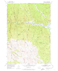
1954 Map of Silver City
USGS Topo · Published 1974About this map
Silver City and Canyon City anchor this mid-century look at the Black Hills mining landscape during a period of significant hydrological change. The map documents the Pactola Reservoir while its shorelines were still being defined, with new construction noted along its eastern edges. Mining history is deeply etched into the topography here, with numerous shafts and claims such as the Homestake Mine, Diana Mine, and Queen Bee Mine scattered through the heavily gulched terrain. The rugged interior is further marked by isolated landmarks like Flannigan Cabin and the Bullock Lookout Tower on Scruton Mountain. This survey was conducted just as the Black Hills National Forest was adapting to modern infrastructure, evidenced by the "under construction" notation near the reservoir and the presence of the Pactola Sch, providing a detailed record of Pennington County's resource-driven settlements before they were further altered by 20th-century development.
Find a feature on this map
62 named features on this map. Tap any name to fly to it.
Don’t see what you’re looking for? This feature index may not catch every label — zoom into the map to look around manually.
Map Details
Editions of this 1954 Silver City Map
4 editions found

Other maps of this area

1893 · Rapid
USGS Topo · 1:125,000

1894 · Deadwood
USGS Topo · 1:125,000

1894 · Hermosa
USGS Topo · 1:125,000

1896 · Harney Peak
USGS Topo · 1:125,000

1898 · Rapid
USGS Topo · 1:125,000

1901 · Hermosa
USGS Topo · 1:125,000

1901 · Harney Peak
USGS Topo · 1:125,000

1901 · Deadwood
USGS Topo · 1:125,000

1903 · Rapid
USGS Topo · 1:125,000

1916 · Deadwood
USGS Topo · 1:125,000