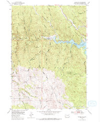
1954 Map of Silver City
USGS Topo · Published 1979About this map
The Black Hills National Forest landscape shown here reflects a mid-century period of significant hydraulic transition. The most striking development is the Pactola Reservoir, noted during its filling phase with a marked under construction road nearby and specific data for the normal elevation and spillway. This massive project transformed the upper Rapid Creek valley, where the small community of Silver City and the historic Canyon City are situated.
Find a feature on this map
64 named features on this map. Tap any name to fly to it.
Don’t see what you’re looking for? This feature index may not catch every label — zoom into the map to look around manually.
Map Details
Editions of this 1954 Silver City Map
4 editions found

Other maps of this area

1893 · Rapid
USGS Topo · 1:125,000

1894 · Deadwood
USGS Topo · 1:125,000

1894 · Hermosa
USGS Topo · 1:125,000

1896 · Harney Peak
USGS Topo · 1:125,000

1898 · Rapid
USGS Topo · 1:125,000

1901 · Hermosa
USGS Topo · 1:125,000

1901 · Harney Peak
USGS Topo · 1:125,000

1901 · Deadwood
USGS Topo · 1:125,000

1903 · Rapid
USGS Topo · 1:125,000

1916 · Deadwood
USGS Topo · 1:125,000