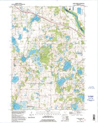
1991 Map of Silver Creek
USGS Topo · Published 1995About this map
The Mississippi River forms the northeastern boundary of this landscape, separating Sherburne and Wright counties. This 1991 revision shows a region defined by complex glacial topography, where numerous lakes and wetlands are protected by established conservation lands. The extensive Lake Maria State Park dominates the central portion of the sheet, surrounded by specialized habitats like the Hoglund State Wildlife Management Area and the Kelly-Meyer State Wildlife Management Area.
Find a feature on this map
32 named features on this map. Tap any name to fly to it.
Don’t see what you’re looking for? This feature index may not catch every label — zoom into the map to look around manually.
Map Details
Editions of this 1991 Silver Creek Map
This is the sole edition of this map. No revisions or reprints were ever made.
Other maps of this area

1951 · Annandale
USGS Topo · 1:62,500

1953 · Saint Cloud
USGS Topo · 1:250,000

1953 · Stillwater
USGS Topo · 1:250,000

1955 · Stillwater
USGS Topo · 1:250,000

1957 · Saint Cloud
USGS Topo · 1:250,000

1958 · Stillwater
USGS Topo · 1:250,000

1958 · Saint Cloud
USGS Topo · 1:250,000

1958 · Buffalo
USGS Topo · 1:62,500

1958 · Cokato
USGS Topo · 1:62,500

1961 · Clear Lake
USGS Topo · 1:24,000