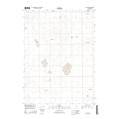
2015 Map of Silver Lake
USGS Topo · Published 2015About this map
Silver Lake and the smaller Shallow Lake dominate the central basins of this high-desert landscape in Elko County. The terrain is characterized by broad alluvial flats and gentle rises, typical of the northern Great Basin, where seasonal water accumulation creates these distinctive alkaline features. To the north, Twelvemile Flat provides a level expanse between undulating ridges, while the Monument Hills rise in the east-central portion of the quadrangle. The southern reach of the map transitions into the arid expanse of the Owyhee Desert, a region defined by its isolation and sparse vegetation. This 2015 survey by the U.S. Geological Survey provides a precise view of the hydrology and topography of this undeveloped area, including the public land survey system grid lines that organize the ranching and resource lands of northern Nevada.
Find a feature on this map
11 named features on this map. Tap any name to fly to it.
Don’t see what you’re looking for? This feature index may not catch every label — zoom into the map to look around manually.
Map Details
Editions of this 2015 Silver Lake Map
This is the sole edition of this map. No revisions or reprints were ever made.
Other maps of this area

1955 · McDermitt
USGS Topo · 1:250,000

1959 · McDermitt
USGS Topo · 1:250,000

1973 · McCleary Wells
USGS Topo · 1:24,000

1973 · Corral Lake
USGS Topo · 1:24,000

1973 · Twelvemile Flat
USGS Topo · 1:24,000
1973 · Star Valley Ridge SE
USGS Topo · 1:24,000
1974 · Twelvemile Flat SE
USGS Topo · 1:24,000

1974 · Middle Draw Reservoir
USGS Topo · 1:24,000

1974 · Winters Ranch Reservoir
USGS Topo · 1:24,000

1974 · Desert Ranch
USGS Topo · 1:24,000