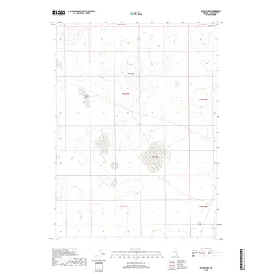
2018 Map of Silver Lake
USGS Topo · Published 2018About this map
Monument Hills rise above a landscape of high-desert basins in this Elko County quadrangle, where the ephemeral hydrology of the Great Basin is on full display. The northern section is dominated by the vast Twelvemile Flat, while the central and southern portions of the map are defined by seasonal water bodies including Silver Lake and Shallow Lake. These dry lake beds, or playas, signify a topography shaped by internal drainage, characteristic of the northern reaches of the Owyhee Desert. The map reveals a remote area primarily utilized for grazing and land management, delineated by the Public Land Survey System grids across several townships, with little in the way of permanent human settlement but significant evidence of the region's complex natural drainage patterns.
Find a feature on this map
11 named features on this map. Tap any name to fly to it.
Don’t see what you’re looking for? This feature index may not catch every label — zoom into the map to look around manually.
Map Details
Editions of this 2018 Silver Lake Map
This is the sole edition of this map. No revisions or reprints were ever made.
Other maps of this area

1955 · McDermitt
USGS Topo · 1:250,000

1959 · McDermitt
USGS Topo · 1:250,000

1973 · McCleary Wells
USGS Topo · 1:24,000

1973 · Corral Lake
USGS Topo · 1:24,000

1973 · Twelvemile Flat
USGS Topo · 1:24,000
1973 · Star Valley Ridge SE
USGS Topo · 1:24,000
1974 · Twelvemile Flat SE
USGS Topo · 1:24,000

1974 · Middle Draw Reservoir
USGS Topo · 1:24,000

1974 · Winters Ranch Reservoir
USGS Topo · 1:24,000

1974 · Desert Ranch
USGS Topo · 1:24,000