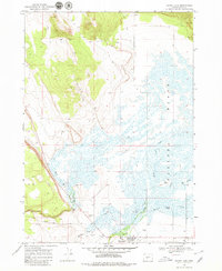
1968 Map of Silver Lake
USGS Topo · Published 1979About this map
Paulina Marsh dominates the eastern half of this Lake County landscape, a complex wetland fed by the convergence of Buck Creek, Silver Creek, and Cowley Creek. During this late-1960s survey, the area south of the marsh supported a concentrated ranching economy, with family-named operations like the ZX Ranch, Lane Ranch, and Linebaugh Ranch established along the periphery of the wetlands. The small settlement of Silver Lake serves as the focal point for the region, positioned near a Landing Strip and the junction of Silver Lake Road. The interplay between the high desert terrain to the west and the riparian environment to the east is marked by several resource extraction sites, including a Cinder Pit and multiple Gravel Pits, which suggest the infrastructure needs of this isolated agricultural community.
Find a feature on this map
20 named features on this map. Tap any name to fly to it.
Don’t see what you’re looking for? This feature index may not catch every label — zoom into the map to look around manually.
Map Details
Editions of this 1968 Silver Lake Map
2 editions found
Other maps of this area

1955 · Crescent
USGS Topo · 1:250,000

1957 · Crescent
USGS Topo · 1:250,000

1958 · Crescent
USGS Topo · 1:250,000

1968 · Silver Lake
USGS Topo · 1:24,000

1968 · Oatman Flat
USGS Topo · 1:24,000
1968 · Hager Mtn
USGS Topo · 1:24,000
1968 · Bridge Creek Draw
USGS Topo · 1:24,000

1970 · Crescent
USGS Topo · 1:250,000

1979 · Crescent
USGS Topo · 1:100,000
1981 · Tuff Butte
USGS Topo · 1:24,000