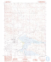
1985 Map of Silver Springs North
USGS Topo · Published 1993About this map
Silver Springs stands as a primary focal point at the intersection of high desert terrain and water-based recreation in this mid-1980s landscape. The map records the juxtaposition of mid-century infrastructure and pioneer history, notably marking the Emigrant Trail (Carson River Route) as it traverses the northern reaches of the Lahontan Reservoir. The historic Hawes Station (Site) is documented near the trail, providing a crucial link for genealogists and historians tracking 19th-century westward migration paths through the Nevada desert.
Find a feature on this map
27 named features on this map. Tap any name to fly to it.
Don’t see what you’re looking for? This feature index may not catch every label — zoom into the map to look around manually.
Map Details
Editions of this 1985 Silver Springs North Map
2 editions found
Other maps of this area

1890 · Wadsworth
USGS Topo · 1:125,000

1891 · Wabuska
USGS Topo · 1:125,000

1892 · Wadsworth
USGS Topo · 1:125,000

1894 · Wadsworth
USGS Topo · 1:125,000

1894 · Wabuska
USGS Topo · 1:125,000

1957 · Churchill Butte
USGS Topo · 1:62,500

1957 · Two Tips
USGS Topo · 1:62,500

1957 · Wadsworth
USGS Topo · 1:62,500

1957 · Silver Springs
USGS Topo · 1:62,500

1957 · Reno
USGS Topo · 1:250,000