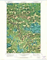
1970 Map of Silverdale
USGS Topo · Published 1973About this map
The Little Fork River meanders heavily through a landscape defined by timber and drainage in this northern Minnesota orthophotomap. Small clearings for agriculture and homesteading appear near the settlement of Silverdale, while the Koochiching State Forest and Kabetogama State Forest cover much of the surrounding territory. This specific map type uses aerial imagery from 1969 to show the literal ground cover, revealing the winding path of the Sturgeon River and its confluence with smaller tributaries like Willow River. Near the intersection of these waterways, the community of Greaney is centered around local landmarks including St Bridgets Ch, providing a clear look at the rural social hubs of the region during the early 1970s. The map also records the jurisdictional boundaries where St. Louis Co meets its neighbors, following section lines through the dense woods.
Find a feature on this map
13 named features on this map. Tap any name to fly to it.
Don’t see what you’re looking for? This feature index may not catch every label — zoom into the map to look around manually.
Map Details
Editions of this 1970 Silverdale Map
This is the sole edition of this map. No revisions or reprints were ever made.
Other maps of this area

1954 · Hibbing
USGS Topo · 1:250,000

1954 · International Falls
USGS Topo · 1:250,000

1957 · Hibbing
USGS Topo · 1:250,000

1957 · International Falls
USGS Topo · 1:250,000

1958 · International Falls
USGS Topo · 1:250,000

1958 · Hibbing
USGS Topo · 1:250,000

1964 · Hibbing
USGS Topo · 1:250,000

1964 · Gheen NW
USGS Topo · 1:24,000
1964 · Meadow Brook
USGS Topo · 1:24,000

1968 · Orr SW
USGS Topo · 1:24,000