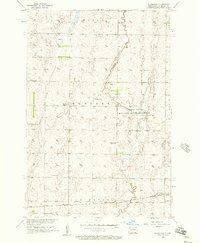
1956 Map of Silverleaf
USGS Topo · Published 1957About this map
The Maple River meanders through this portion of Dickey County, forming the central axis for the Maple River National Wildlife Refuge. This mid-century landscape is defined by the transition from riparian wetlands to a structured agricultural grid, where townships like Kenter, Ada, and Van Meter meet. The transportation and social infrastructure of the era is anchored by the Great Northern railroad in the south, which served the station at Silverleaf.
Find a feature on this map
14 named features on this map. Tap any name to fly to it.
Don’t see what you’re looking for? This feature index may not catch every label — zoom into the map to look around manually.
Map Details
Editions of this 1956 Silverleaf Map
This is the sole edition of this map. No revisions or reprints were ever made.
Other maps of this area

1894 · Monango
USGS Topo · 1:62,500

1894 · Ellendale
USGS Topo · 1:62,500

1894 · Savo
USGS Topo · 1:62,500

1894 · Fullerton
USGS Topo · 1:62,500

1895 · Lamoure
USGS Topo · 1:125,000

1896 · Columbia
USGS Topo · 1:125,000

1896 · Edgeley
USGS Topo · 1:125,000

1899 · Ellendale
USGS Topo · 1:125,000

1918 · La Moure
USGS Topo · 1:125,000

1925 · Edgeley
USGS Topo · 1:125,000