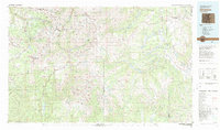
1982 Map of Silverton
USGS Topo · Published 1983About this map
Silverton and Telluride anchor this survey of the high San Juan Mountains, illustrating a landscape defined by its deep-rooted mining history and high-altitude transport corridors. In the early 1980s, the map records the enduring legacy of the San Juan silver and gold boom through the presence of legendary operations like the Camp Bird Mine, Tomboy Mine, and the Shenandoah-Dives Mine. The narrow-gauge tracks of the D & R G W RR follow the Animas River south of Silverton, passing through isolated stops like Elk Park and Needleton. This map demonstrates the transition from industrial extractivism to recreation and preservation, with vast areas now designated as the Weminuche Wilderness and Mount Sneffels Wilderness. These protected lands surround older, formerly bustling camps such as Eureka, Gladstone, and Howardsville, providing a spatial record of the region's mining districts and their connectivity across the Continental Divide.
Find a feature on this map
121 named features on this map. Tap any name to fly to it.
Don’t see what you’re looking for? This feature index may not catch every label — zoom into the map to look around manually.
Map Details
Editions of this 1982 Silverton Map
3 editions found
Other maps of this area

1895 · La Plata
USGS Topo · 1:62,500

1897 · La Plata
USGS Topo · 1:62,500

1897 · Rico
USGS Topo · 1:62,500

1897 · Telluride
USGS Topo · 1:62,500

1897 · Silverton
USGS Topo · 1:62,500

1898 · Durango
USGS Topo · 1:62,500

1898 · Engineer Mountain
USGS Topo · 1:62,500

1898 · Rico
USGS Topo · 1:62,500

1899 · La Plata
USGS Topo · 1:62,500

1899 · Rico
USGS Topo · 1:62,500