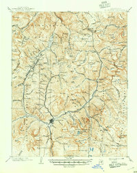
1902 Map of Silverton
USGS Topo · Published 1946About this map
Silverton serves as the hub of this high-altitude mining landscape at the turn of the century, where narrow-gauge rail lines penetrate deep into the San Juan Mountains. The Silverton Northern R. R. and the D. & R. G. R. R. follow the corridors of the Animas River and its tributaries to reach remote camps like Eureka, Animas Forks, and Mineral Point. The map captures the peak of the region's extraction era, with the notorious Red Mountain district and the Campbird mine connected by a web of mountain trails and rugged roads. This survey illustrates how the vertical geography influenced settlement, forcing towns like Gladstone and Howardsville into the narrow basins below summits like Potosi Peak and Sultan Mt. High-country basins such as Richmond Basin and Arrastre Basin are clearly defined, showing the intense prospecting that defined the San Juan, Uncompahgre, and Rio Grande national forests before modern consolidation.
Find a feature on this map
163 named features on this map. Tap any name to fly to it.
Don’t see what you’re looking for? This feature index may not catch every label — zoom into the map to look around manually.
Map Details
Editions of this 1902 Silverton Map
4 editions found
Other maps of this area

1897 · Telluride
USGS Topo · 1:62,500

1897 · Silverton
USGS Topo · 1:62,500

1898 · Engineer Mountain
USGS Topo · 1:62,500

1900 · Engineer Mountain
USGS Topo · 1:62,500

1900 · Needle Mountains
USGS Topo · 1:62,500

1901 · Silverton
USGS Topo · 1:62,500

1902 · Needle Mountains
USGS Topo · 1:62,500

1902 · Silverton
USGS Topo · 1:62,500

1902 · Ouray
USGS Topo · 1:62,500

1903 · Lake City
USGS Topo · 1:62,500