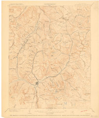
1902 Map of Silverton
USGS Topo · Published 1910About this map
The Silverton Northern and Denver and Rio Grande railroads converge at the town of Silverton, the industrial and transportation hub for a high-altitude mining district at the turn of the century. Following the winding course of the Animas River and its various forks, these rail lines served a network of remote alpine settlements including Eureka, Animas Forks, and Howardsville. The landscape is defined by its verticality, with mining operations like the Campbird and Champion Basin situated among prominent peaks such as Sultan Mt. and King Solomon Mt.. This survey records the intensive extraction era before many of these camps were consolidated or reached their peak output, showing the early infrastructure of the San Juan and Hinsdale county regions. Evidence of the hydraulic and geological intensity of the era is visible in the naming of numerous basins and gulches like Poughkeepsie Gulch and Cataract Gulch that fed the regional river systems.
Find a feature on this map
123 named features on this map. Tap any name to fly to it.
Don’t see what you’re looking for? This feature index may not catch every label — zoom into the map to look around manually.
Map Details
Editions of this 1902 Silverton Map
4 editions found
Other maps of this area

1897 · Telluride
USGS Topo · 1:62,500

1897 · Silverton
USGS Topo · 1:62,500

1898 · Engineer Mountain
USGS Topo · 1:62,500

1900 · Engineer Mountain
USGS Topo · 1:62,500

1900 · Needle Mountains
USGS Topo · 1:62,500

1901 · Silverton
USGS Topo · 1:62,500

1902 · Needle Mountains
USGS Topo · 1:62,500

1902 · Silverton
USGS Topo · 1:62,500

1902 · Ouray
USGS Topo · 1:62,500

1903 · Lake City
USGS Topo · 1:62,500