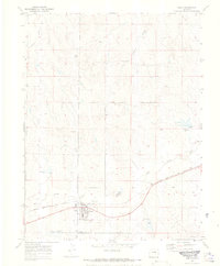
1970 Map of Simla
USGS Topo · Published 1973About this map
Simla serves as the primary hub of this eastern Elbert County landscape, situated along the Chicago Rock Island and Pacific railroad. The town's grid is detailed with local infrastructure including the Big Sandy Sch, an Athletic Field, and Big Sandy Sch Water Tanks. Outside the town center, the terrain is defined by the drainage of Big Sandy Creek and its tributaries such as Reed Springs Creek and Sixshooter Gulch. This 1970 field-checked survey reveals a rural landscape managed through water engineering, featuring multiple spillways like Spillway 6016 and Spillway 5858 scattered across the creek valleys. The map also records the boundary line between Elbert Co El Paso Co, providing a clear view of the jurisdictional and physical layout of the High Plains before modern expansion.
Find a feature on this map
16 named features on this map. Tap any name to fly to it.
Don’t see what you’re looking for? This feature index may not catch every label — zoom into the map to look around manually.
Map Details
Editions of this 1970 Simla Map
4 editions found

Other maps of this area

1891 · Limon
USGS Topo · 1:125,000

1892 · Limon
USGS Topo · 1:125,000

1953 · Denver
USGS Topo · 1:250,000

1954 · Limon
USGS Topo · 1:250,000

1957 · Denver
USGS Topo · 1:250,000

1957 · Limon
USGS Topo · 1:250,000

1958 · Limon
USGS Topo · 1:250,000

1958 · Denver
USGS Topo · 1:250,000

1960 · Denver
USGS Topo · 1:250,000
1970 · Matheson SW
USGS Topo · 1:24,000