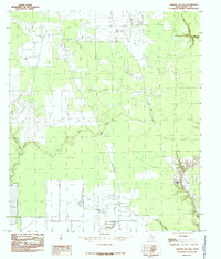
1984 Map of Simmons Bottom
USGS Topo · Published 1985About this map
Simmons Bottom and its surrounding wetlands define the low-lying geography of this corner of Liberty County during the mid-1970s and early 1980s. The landscape is dominated by a complex hydrological network where Luce Bayou and Tarkington Bayou converge, creating a riparian environment characterized by slow-moving water and seasonal inundation. To the northeast, the terrain transitions into the Prairie Marsh and a feature simply identified as the Gully, while Long John Creek drains the southern reaches of the quadrangle. This 1984 provisional survey captures the region just as modern infrastructure, including a network of pipelines and service roads, began to cut across the traditional bottomlands. For those researching the environmental history of the Trinity River basin, the map provides a precise record of the natural drainage patterns and land-use divisions before further suburban expansion or industrial development altered the local water table.
Find a feature on this map
7 named features on this map. Tap any name to fly to it.
Don’t see what you’re looking for? This feature index may not catch every label — zoom into the map to look around manually.
Map Details
Editions of this 1984 Simmons Bottom Map
This is the sole edition of this map. No revisions or reprints were ever made.
Other maps of this area

1916 · Huffman
USGS Topo · 1:24,000

1920 · Huffman
USGS Topo · 1:31,680

1943 · Liberty
USGS Topo · 1:125,000

1954 · Beaumont
USGS Topo · 1:250,000

1955 · Rayburn
USGS Topo · 1:62,500

1955 · Liberty
USGS Topo · 1:62,500

1957 · Beaumont
USGS Topo · 1:250,000

1958 · Cleveland
USGS Topo · 1:24,000

1959 · Plum Grove
USGS Topo · 1:24,000
1960 · Huffman
USGS Topo · 1:24,000