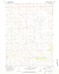
1970 Map of Simpson Draw
USGS Topo · Published 1973About this map
Shawnee Creek and its tributaries carve a network of drainage channels across this high plains landscape of Converse County. The 1970 field check documents a rural ranching environment defined by scattered holdings such as Sybrant, Hall Ranch, and York Ranch. The topographic detail reveals the intricate erosion patterns of Simpson Draw and the West Fork Simpson Draw, where seasonal water flow has shaped the terrain. While predominantly agricultural, the appearance of a Gas Well in the eastern section hints at the early energy exploration that would eventually expand in the Powder River Basin. Numerous survey markers, including BM 5398 Arrow, provide precise historical elevation data for researchers and land historians tracking the development of the region's boundary lines and infrastructure.
Find a feature on this map
15 named features on this map. Tap any name to fly to it.
Don’t see what you’re looking for? This feature index may not catch every label — zoom into the map to look around manually.
Map Details
Editions of this 1970 Simpson Draw Map
2 editions found
Other maps of this area

1949 · Shawnee
USGS Topo · 1:24,000

1949 · Irvine
USGS Topo · 1:24,000

1949 · Clausen Ranch
USGS Topo · 1:24,000

1949 · Orin
USGS Topo · 1:24,000

1949 · Antelope Creek
USGS Topo · 1:24,000

1950 · Clausen Ranch
USGS Topo · 1:24,000

1950 · Orin
USGS Topo · 1:24,000
1950 · Irvine
USGS Topo · 1:24,000
1950 · Antelope Creek
USGS Topo · 1:24,000

1950 · Shawnee
USGS Topo · 1:24,000