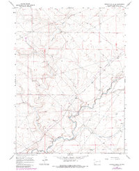
1968 Map of Simpson Gulch SE
USGS Topo · Published 1980About this map
The Emigrant Trail traverses this high-desert landscape in Sweetwater County, following a path through a terrain defined by dramatic drainage systems. The Big Sandy River meanders across the southern and eastern portions of the quadrangle, serving as the primary hydrological feature. Its course is joined by several dry washes and seasonal tributaries, including Simpson Gulch, Carlson Draw, and Bone Draw.
Find a feature on this map
14 named features on this map. Tap any name to fly to it.
Don’t see what you’re looking for? This feature index may not catch every label — zoom into the map to look around manually.
Map Details
Editions of this 1968 Simpson Gulch SE Map
2 editions found
Other maps of this area

1954 · Rock Springs
USGS Topo · 1:250,000

1955 · Lander
USGS Topo · 1:250,000

1958 · Lander
USGS Topo · 1:250,000

1958 · Rock Springs
USGS Topo · 1:250,000

1961 · Lander
USGS Topo · 1:250,000

1962 · Rock Springs
USGS Topo · 1:250,000

1963 · Gasson Bridge
USGS Topo · 1:24,000

1963 · Pittman Well
USGS Topo · 1:24,000

1968 · Farson
USGS Topo · 1:24,000

1968 · Twelvemile Knoll
USGS Topo · 1:24,000