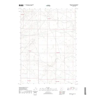
2017 Map of Simpson Gulch SW
USGS Topo · Published 2017About this map
The high desert terrain of Sweetwater County is organized into the rigid grids of the Public Land Survey System in this 2017 topographic study. The landscape is defined by its township and range divisions, including T25n R109w, T25n R108w, and T24n R109w. This area of Wyoming represents a vast expanse of open country where modern infrastructure meets historical land management boundaries. Surveyed by the U.S. Geological Survey, the map provides precise contour data across T24n R108w and down to T23n R108w, illustrating the subtle elevation shifts and drainages of this arid region. The lack of named settlements or civic institutions underscores the remote character of these high-altitude plains, where the primary human footprint is found in the section lines and township markers that delineate the high-plains geography south of the continental divide.
Find a feature on this map
6 named features on this map. Tap any name to fly to it.
Don’t see what you’re looking for? This feature index may not catch every label — zoom into the map to look around manually.
Map Details
Editions of this 2017 Simpson Gulch SW Map
This is the sole edition of this map. No revisions or reprints were ever made.
Other maps of this area

1954 · Rock Springs
USGS Topo · 1:250,000

1955 · Lander
USGS Topo · 1:250,000

1958 · Lander
USGS Topo · 1:250,000

1958 · Rock Springs
USGS Topo · 1:250,000

1961 · Lander
USGS Topo · 1:250,000

1962 · Rock Springs
USGS Topo · 1:250,000

1963 · Gasson Bridge
USGS Topo · 1:24,000

1963 · Pittman Well
USGS Topo · 1:24,000
1963 · Thoman School
USGS Topo · 1:24,000
1968 · Twelvemile Sink
USGS Topo · 1:24,000