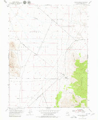
1955 Map of Simpson Springs
USGS Topo · Published 1979About this map
Simpson Springs serves as a vital oasis in the West Desert of Tooele County, captured here during mid-century topographic surveys. The landscape is dominated by the massive Dugway Proving Ground military installation, which occupies a significant portion of the northern and western terrain. This map highlights the intersection of military utility and pioneering history, as the Pony Express Route cuts diagonally across the desert floor toward the mountains. A Pony Express Historic Marker and Water Tank denote the significance of the springs as a reliable water source in an arid environment. To the east, the topography rises sharply into the Simpson Mts, featuring landmarks like Simpson Point and the winding Simpson Canyon. The map traces a network of remote transportation lines, including the Simpson Springs-Callao Road and several Jeep Trails that navigate the slopes of Simpson Buttes.
Find a feature on this map
18 named features on this map. Tap any name to fly to it.
Don’t see what you’re looking for? This feature index may not catch every label — zoom into the map to look around manually.
Map Details
Editions of this 1955 Simpson Springs Map
3 editions found
Other maps of this area

1885 · Sevier Desert
USGS Topo · 1:250,000

1885 · Tooele Valley
USGS Topo · 1:250,000

1953 · Tooele
USGS Topo · 1:250,000

1953 · Delta
USGS Topo · 1:250,000

1954 · Camels Back Ridge NW
USGS Topo · 1:24,000

1955 · Camels Back Ridge SW
USGS Topo · 1:24,000

1955 · Simpson Springs
USGS Topo · 1:24,000

1955 · Indian Peaks
USGS Topo · 1:24,000

1955 · Indian Springs
USGS Topo · 1:24,000

1955 · Camels Back Ridge NE
USGS Topo · 1:24,000