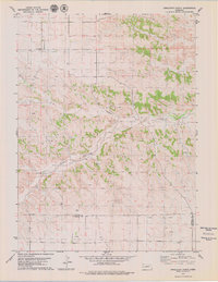
1979 Map of Singleton Ranch
USGS Topo · Published 1979About this map
Singleton Ranch sits at the heart of this Western Nebraska landscape, where the high plains are carved by the drainage of Lawrence Fork. Recorded in the late 1970s, the map reveals a region defined by large-scale ranching and an active petroleum industry. The presence of an extensive Oil Field and numerous Oil Wells scattered across the township lines indicates the economic importance of mineral extraction during this era. Social centers are sparse but significant, represented by the Kirk Chapel and the small settlement at Beard. The topography is notably marked by Rocky Hollow, which cuts through the central portion of the quadrangle. This survey captures a moment when traditional land use intersected with energy development, providing a clear view of the county boundaries between Banner and Kimball and Cheyenne counties.
Find a feature on this map
10 named features on this map. Tap any name to fly to it.
Don’t see what you’re looking for? This feature index may not catch every label — zoom into the map to look around manually.
Map Details
Editions of this 1979 Singleton Ranch Map
This is the sole edition of this map. No revisions or reprints were ever made.
Other maps of this area

1898 · Scotts Bluff
USGS Topo · 1:125,000

1898 · Camp Clarke
USGS Topo · 1:125,000

1954 · Scottsbluff
USGS Topo · 1:250,000

1958 · Scottsbluff
USGS Topo · 1:250,000

1973 · Potter 2 SW
USGS Topo · 1:24,000

1973 · Scotts Bluff 4 SE
USGS Topo · 1:24,000

1973 · Kimball 1 SE
USGS Topo · 1:24,000

1973 · Kimball 1 NE
USGS Topo · 1:24,000

1973 · Potter 2 SE
USGS Topo · 1:24,000

1973 · Potter 2 NW
USGS Topo · 1:24,000