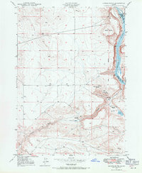
1948 Map of Sinker Butte
USGS Topo · Published 1971About this map
The Boise Emigrant Trail follows the canyon rim above the Snake River in this post-war landscape of the high Idaho desert. This map documents a rugged river corridor where history and infrastructure meet, specifically at the Otter Massacre Site and the nearby Jacob Reuben Graves located on the bench above Sinker Creek. These markers reflect the challenges of 19th-century westward migration along the trail. By the late 1940s, the area had transitioned into a land of ranching and early utility development, shown by the Gabica Ranch and Montini Ranch alongside the Swan Falls Power Plant at the river's edge. The terrain is dominated by prominent volcanic features like Sinker Butte and Sinker Creek Butte, providing a stark backdrop to the numerous wells and springs scattered across the plateau for livestock.
Find a feature on this map
14 named features on this map. Tap any name to fly to it.
Don’t see what you’re looking for? This feature index may not catch every label — zoom into the map to look around manually.
Map Details
Editions of this 1948 Sinker Butte Map
2 editions found
Other maps of this area

1892 · Bisuka
USGS Topo · 1:125,000

1892 · Silver City
USGS Topo · 1:125,000

1894 · Bisuka
USGS Topo · 1:125,000

1894 · Silver City
USGS Topo · 1:125,000

1898 · Silver City
USGS Topo · 1:125,000

1947 · Wild Horse Butte
USGS Topo · 1:24,000

1948 · Castle Butte
USGS Topo · 1:24,000

1948 · Wild Horse Butte
USGS Topo · 1:24,000

1948 · Sinker Butte
USGS Topo · 1:24,000

1949 · Sinker Butte
USGS Topo · 1:24,000