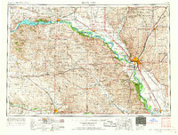
1955 Map of Sioux City
USGS Topo · Published 1967About this map
Lewis and Clark Lake dominates the northwestern corner of this mid-century survey, held back by the prominent Gavins Point Dam on the Missouri River. The landscape reveals a dense network of rural infrastructure typical of the era, where small township schools such as Mission Hill School and Daisy Valley School served the agricultural communities of eastern Nebraska and western Iowa. Significant institutional footprints are visible at the Yankton State Hospital and Norfolk State Hospital, while the presence of the Santee Indian Reservation, Winnebago Indian Reservation, and Omaha Indian Reservation highlights the complex land divisions of the region. The map also traces the corridors of the Chicago and North Western and Great Northern railroads, which facilitated the movement of goods and people between regional hubs like Sioux City and Yankton.
Find a feature on this map
286 named features on this map. Tap any name to fly to it.
Don’t see what you’re looking for? This feature index may not catch every label — zoom into the map to look around manually.
Map Details
Editions of this 1955 Sioux City Map
4 editions found

Other maps of this area

1897 · Canton
USGS Topo · 1:125,000

1898 · Olivet
USGS Topo · 1:125,000

1898 · Parker
USGS Topo · 1:125,000

1898 · Elk Point
USGS Topo · 1:125,000

1900 · Canton
USGS Topo · 1:125,000

1901 · Elk Point
USGS Topo · 1:125,000

1907 · Elk Point
USGS Topo · 1:125,000

1950 · Niobrara
USGS Topo · 1:24,000

1950 · Verdigre NE
USGS Topo · 1:24,000

1954 · Verdigre
USGS Topo · 1:24,000