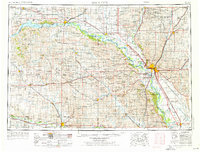
1955 Map of Sioux City
USGS Topo · Published 1976About this map
The Missouri River serves as the dominant spine of this mid-century landscape, carving a wide valley that separates the South Dakota-Nebraska and South Dakota-Iowa borders. The newly formed Lewis and Clark Lake, created by the Gavins Point Dam near Yankton, indicates the era's significant hydro-engineering efforts to control the river's flow. This map documents a critical junction of agriculture and education, anchoring the region with institutions like the University of South Dakota in Vermillion and Wayne State College in Wayne.
Find a feature on this map
286 named features on this map. Tap any name to fly to it.
Don’t see what you’re looking for? This feature index may not catch every label — zoom into the map to look around manually.
Map Details
Editions of this 1955 Sioux City Map
4 editions found

Other maps of this area

1897 · Canton
USGS Topo · 1:125,000

1898 · Olivet
USGS Topo · 1:125,000

1898 · Parker
USGS Topo · 1:125,000

1898 · Elk Point
USGS Topo · 1:125,000

1900 · Canton
USGS Topo · 1:125,000

1901 · Elk Point
USGS Topo · 1:125,000

1907 · Elk Point
USGS Topo · 1:125,000

1950 · Niobrara
USGS Topo · 1:24,000

1950 · Verdigre NE
USGS Topo · 1:24,000

1954 · Verdigre
USGS Topo · 1:24,000