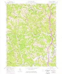
1958 Map of Sissonville
USGS Topo · Published 1976About this map
The Pocatalico River carves a winding path through the dissected plateau of Kanawha and Putnam Counties, defining a landscape where narrow ridges like Leffers Ridge and Hogpen Ridge overlook deeply etched hollows. In the mid-1950s, this region remained characterized by small, dispersed rural settlements and a dense network of country schools and churches. Sissonville serves as a primary hub along the river, while smaller communities like Liberty and Goldtown anchor the surrounding hills. The map captures an era of specific local infrastructure, showing numerous gas wells and institutions like the Unexpected Sch and Point Harmony Sch. An intricate web of drainage, including Derrick Creek and Allen Fork, dictates the placement of winding roads and hillside cemeteries such as the Rock Spring Cem. This survey illustrates the transition of a traditional Appalachian rural economy as it began to integrate modern utility corridors and a local Golf Course.
Find a feature on this map
94 named features on this map. Tap any name to fly to it.
Don’t see what you’re looking for? This feature index may not catch every label — zoom into the map to look around manually.
Map Details
Editions of this 1958 Sissonville Map
4 editions found
Other maps of this area

1899 · Charleston
USGS Topo · 1:125,000

1906 · Kenna
USGS Topo · 1:62,500

1906 · Winfield
USGS Topo · 1:62,500

1907 · Kenna
USGS Topo · 1:62,500

1908 · Winfield
USGS Topo · 1:62,500

1909 · Charleston
USGS Topo · 1:62,500

1909 · Saint Albans
USGS Topo · 1:62,500

1931 · Saint Albans
USGS Topo · 1:62,500

1931 · Charleston
USGS Topo · 1:62,500

1933 · Saint Albans
USGS Topo · 1:62,500