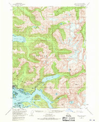
1951 Map of Sitka A-4
USGS Topo · Published 1970About this map
Sitka serves as the focal point for this mid-century coastal survey on Baranof Island. The map documents a period of significant hydroelectric and infrastructure development, evidenced by the tunnel and spillway near Blue Lake, which were central to the area's power and water needs. The town's maritime and aviation importance is highlighted by the Seaplane Base on the shoreline of Crescent Bay, while the National Cemetery and Sitka Highway anchor the terrestrial geography. Much of the surrounding landscape remains dominated by the Tongass National Forest, where the terrain rises sharply from the Eastern Channel to named peaks like Mt Verstovia and Arrowhead Peak. The intricate network of islands, including Katz I, Kutkan I, and Cannon I, illustrates the complex navigation required in the waters of Silver Bay and Jamestown Bay.
Find a feature on this map
90 named features on this map. Tap any name to fly to it.
Don’t see what you’re looking for? This feature index may not catch every label — zoom into the map to look around manually.
Map Details
Editions of this 1951 Sitka A-4 Map
4 editions found

Other maps of this area

1948 · Sitka B-3
USGS Topo · 1:63,360

1948 · Sitka A-5
USGS Topo · 1:63,360

1948 · Sitka A-3
USGS Topo · 1:63,360

1948 · Sitka B-5
USGS Topo · 1:63,360

1951 · Sitka B-4
USGS Topo · 1:63,360

1951 · Sitka B-5
USGS Topo · 1:63,360

1951 · Port Alexander D-5
USGS Topo · 1:63,360

1951 · Sitka
USGS Topo · 1:250,000

1951 · Port Alexander D-4
USGS Topo · 1:63,360

1951 · Port Alexander D-3
USGS Topo · 1:63,360