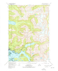
1951 Map of Sitka A-4
USGS Topo · Published 1977About this map
Sitka serves as the focal point of this coastal survey, where the town's historical geography is detailed alongside the Sitka Nat Mon and the National Cemetery. The landscape is dominated by the steep ascent from the Eastern Channel and Silver Bay to the prominent peaks of Mt Verstovia and Sugarloaf Mountain. Water management and natural resources are evident through the presence of the Spillway and Tunnel near Blue Lake, as well as numerous named streams like Sawmill Creek and the Indian River.
Find a feature on this map
83 named features on this map. Tap any name to fly to it.
Don’t see what you’re looking for? This feature index may not catch every label — zoom into the map to look around manually.
Map Details
Editions of this 1951 Sitka A-4 Map
4 editions found

Other maps of this area

1948 · Sitka B-3
USGS Topo · 1:63,360

1948 · Sitka A-5
USGS Topo · 1:63,360

1948 · Sitka A-3
USGS Topo · 1:63,360

1948 · Sitka B-5
USGS Topo · 1:63,360

1951 · Sitka B-4
USGS Topo · 1:63,360

1951 · Sitka B-5
USGS Topo · 1:63,360

1951 · Port Alexander D-5
USGS Topo · 1:63,360

1951 · Sitka
USGS Topo · 1:250,000

1951 · Port Alexander D-4
USGS Topo · 1:63,360

1951 · Port Alexander D-3
USGS Topo · 1:63,360