
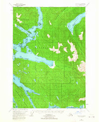
1948 Map of Sitka B-5
USGS Topo · Published 1983About this map
Baranof Island and the surrounding Alexander Archipelago waters define this maritime landscape in the late 1940s. The map captures a complex network of waterways essential for coastal navigation and resource access, including the treacherous Sergius Narrows and the sheltered Haley Anchorage. Large-scale topographic detail reveals the dense coastal forests of the Tongass National Forest and the steep elevation changes rising directly from the tidewater. Evidence of human presence is sparse but specific, marked by remote outposts like Highwater Cabin and unnamed Cabins at the head of Nakwasina Passage. The separation of Chichagof Island from the mainland by the Peril Strait highlights the isolation and nautical dependence of these settlements. For those researching Alaskana, the map provides precise locations for historically named points, bays, and narrows such as Kakul Narrows and St John Baptist Bay before significant modern development.
Find a feature on this map
23 named features on this map. Tap any name to fly to it.
Don’t see what you’re looking for? This feature index may not catch every label — zoom into the map to look around manually.
Map Details
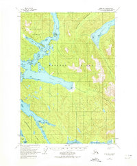
Editions of this 1948 Sitka B-5 Map
3 editions found
Historical Maps of Sitka Through Time
247 maps found

1948 Port Alexander A-2
Sitka Borough, AK

1948 Port Alexander A-3
Sitka Borough, AK

1948 Port Alexander B-2
Sitka Borough, AK

1948 Sitka A-3
Sitka Borough, AK

1948 Sitka A-5
Sitka Borough, AK

1948 Sitka B-3
Sitka Borough, AK
1948 Sitka B-5
Sitka Borough, AK

1948 Sitka C-3
Sitka Borough, AK

1948 Sitka C-6
Sitka Borough, AK

1948 Sitka C-7
Sitka Borough, AK

1948 Sitka D-6
Sitka Borough, AK

1951 Port Alexander A-2
Sitka Borough, AK

1951 Port Alexander A-3
Sitka Borough, AK

1951 Port Alexander B-2
Sitka Borough, AK

1951 Port Alexander B-3 and B-4
Sitka Borough, AK

1951 Port Alexander C-2
Sitka Borough, AK

1951 Port Alexander C-3
Sitka Borough, AK

1951 Port Alexander C-4
Sitka Borough, AK

1951 Port Alexander D-3
Sitka Borough, AK

1951 Port Alexander D-4
Sitka Borough, AK

1951 Port Alexander D-5
Sitka Borough, AK

1951 Port Alexander
Sitka Borough, AK

1951 Sitka A-3
Sitka Borough, AK

1951 Sitka A-4
Sitka Borough, AK

1951 Sitka A-5
Sitka Borough, AK

1951 Sitka A-6
Sitka Borough, AK

1951 Sitka B-3
Sitka Borough, AK

1951 Sitka B-4
Sitka Borough, AK

1951 Sitka B-5
Sitka Borough, AK

1951 Sitka B-6
Sitka Borough, AK

1951 Sitka C-3
Sitka Borough, AK

1951 Sitka C-4
Sitka Borough, AK

1951 Sitka C-5
Sitka Borough, AK

1951 Sitka C-6
Sitka Borough, AK

1951 Sitka C-7
Sitka Borough, AK

1951 Sitka D-6
Sitka Borough, AK

1952 Port Alexander
Sitka Borough, AK

1954 Sitka A-4
Sitka Borough, AK

1964 Port Alexander
Sitka Borough, AK

1987 Sitka A-4 SW
Sitka Borough, AK

1987 Sitka A-5 SE
Sitka Borough, AK

1994 Port Alexander C-3
Sitka Borough, AK

1994 Port Alexander C-4
Sitka Borough, AK

1994 Sitka C-7
Sitka Borough, AK

1995 Port Alexander D-3
Sitka Borough, AK

1996 Sitka A-3
Sitka Borough, AK

1996 Sitka A-5
Sitka Borough, AK

1996 Sitka B-5
Sitka Borough, AK

1996 Sitka B-6
Sitka Borough, AK

1997 Sitka B-3
Sitka Borough, AK

1997 Sitka C-3
Sitka Borough, AK

2000 Sitka D-6
Sitka Borough, AK

2017 Port Alexander A-2 NW
Sitka Borough, AK

2017 Port Alexander A-3 NE
Sitka Borough, AK

2017 Port Alexander B-2 NW
Sitka Borough, AK

2017 Port Alexander B-2 SW
Sitka Borough, AK

2017 Port Alexander B-3 NE
Sitka Borough, AK

2017 Port Alexander B-3 NW
Sitka Borough, AK

2017 Port Alexander B-3 SE
Sitka Borough, AK

2017 Port Alexander B-3 SW
Sitka Borough, AK

2017 Port Alexander B-4 NE
Sitka Borough, AK

2017 Port Alexander C-2 NE
Sitka Borough, AK

2017 Port Alexander C-2 NW
Sitka Borough, AK

2017 Port Alexander C-2 SW
Sitka Borough, AK

2017 Port Alexander C-3 NE
Sitka Borough, AK

2017 Port Alexander C-3 NW
Sitka Borough, AK

2017 Port Alexander C-3 SE
Sitka Borough, AK

2017 Port Alexander C-3 SW
Sitka Borough, AK

2017 Port Alexander C-4 NE
Sitka Borough, AK

2017 Port Alexander C-4 NW
Sitka Borough, AK

2017 Port Alexander C-4 SE
Sitka Borough, AK

2017 Port Alexander D-2 SW
Sitka Borough, AK

2017 Port Alexander D-3 NE
Sitka Borough, AK

2017 Port Alexander D-3 NW
Sitka Borough, AK

2017 Port Alexander D-3 SE
Sitka Borough, AK

2017 Port Alexander D-3 SW
Sitka Borough, AK

2017 Port Alexander D-4 NE
Sitka Borough, AK

2017 Port Alexander D-4 NW
Sitka Borough, AK

2017 Port Alexander D-4 SE
Sitka Borough, AK

2017 Port Alexander D-4 SW
Sitka Borough, AK

2017 Port Alexander D-5 NE
Sitka Borough, AK

2017 Port Alexander D-5 NW
Sitka Borough, AK

2017 Port Alexander D-5 SE
Sitka Borough, AK

2017 Port Alexander D-5 SW
Sitka Borough, AK

2017 Sitka A-3 NE
Sitka Borough, AK

2017 Sitka A-3 NW
Sitka Borough, AK

2017 Sitka A-3 SE
Sitka Borough, AK

2017 Sitka A-3 SW
Sitka Borough, AK

2017 Sitka A-4 NE
Sitka Borough, AK

2017 Sitka A-4 NW
Sitka Borough, AK

2017 Sitka A-4 SE
Sitka Borough, AK

2017 Sitka A-4 SW
Sitka Borough, AK

2017 Sitka A-5 NE
Sitka Borough, AK

2017 Sitka A-5 NW
Sitka Borough, AK

2017 Sitka A-5 SE
Sitka Borough, AK

2017 Sitka A-5 SW
Sitka Borough, AK

2017 Sitka A-6 NE
Sitka Borough, AK

2017 Sitka A-6 NW
Sitka Borough, AK

2017 Sitka A-6 OE S NE
Sitka Borough, AK

2017 Sitka A-6 OE S NW
Sitka Borough, AK

2017 Sitka A-6 SE
Sitka Borough, AK

2017 Sitka A-6 SW
Sitka Borough, AK

2017 Sitka B-3 NE
Sitka Borough, AK

2017 Sitka B-3 NW
Sitka Borough, AK

2017 Sitka B-3 SE
Sitka Borough, AK

2017 Sitka B-3 SW
Sitka Borough, AK

2017 Sitka B-4 NE
Sitka Borough, AK

2017 Sitka B-4 NW
Sitka Borough, AK

2017 Sitka B-4 SE
Sitka Borough, AK

2017 Sitka B-4 SW
Sitka Borough, AK

2017 Sitka B-5 NE
Sitka Borough, AK

2017 Sitka B-5 NW
Sitka Borough, AK

2017 Sitka B-5 SE
Sitka Borough, AK

2017 Sitka B-5 SW
Sitka Borough, AK

2017 Sitka B-6 NE
Sitka Borough, AK

2017 Sitka B-6 NW
Sitka Borough, AK

2017 Sitka B-6 SE
Sitka Borough, AK

2017 Sitka B-6 SW
Sitka Borough, AK

2017 Sitka C-3 NE
Sitka Borough, AK

2017 Sitka C-3 NW
Sitka Borough, AK

2017 Sitka C-3 SE
Sitka Borough, AK

2017 Sitka C-3 SW
Sitka Borough, AK

2017 Sitka C-4 NE
Sitka Borough, AK

2017 Sitka C-4 NW
Sitka Borough, AK

2017 Sitka C-4 SE
Sitka Borough, AK

2017 Sitka C-4 SW
Sitka Borough, AK

2017 Sitka C-5 NE
Sitka Borough, AK

2017 Sitka C-5 NW
Sitka Borough, AK

2017 Sitka C-5 SE
Sitka Borough, AK

2017 Sitka C-5 SW
Sitka Borough, AK

2017 Sitka C-6 NE
Sitka Borough, AK

2017 Sitka C-6 NW
Sitka Borough, AK

2017 Sitka C-6 SE
Sitka Borough, AK

2017 Sitka C-6 SW
Sitka Borough, AK

2017 Sitka C-7 NE
Sitka Borough, AK

2017 Sitka C-7 NW
Sitka Borough, AK

2017 Sitka C-7 OE S NE
Sitka Borough, AK

2017 Sitka C-7 SE
Sitka Borough, AK

2017 Sitka D-5 SE
Sitka Borough, AK

2017 Sitka D-5 SW
Sitka Borough, AK

2017 Sitka D-6 NE
Sitka Borough, AK

2017 Sitka D-6 NW
Sitka Borough, AK

2017 Sitka D-6 SE
Sitka Borough, AK

2017 Sitka D-6 SW
Sitka Borough, AK

2017 Sitka D-7 SE
Sitka Borough, AK

2017 Sitka D-7 SW
Sitka Borough, AK

2017 Sitka D-8 SE
Sitka Borough, AK

2018 Port Alexander C-4 OE W NE
Sitka Borough, AK

2018 Port Alexander C-4 SW
Sitka Borough, AK

2021 Port Alexander A-2 NW
Sitka Borough, AK

2021 Port Alexander A-3 NE
Sitka Borough, AK

2021 Port Alexander B-2 NW
Sitka Borough, AK

2021 Port Alexander B-2 SW
Sitka Borough, AK

2021 Port Alexander B-3 NE
Sitka Borough, AK

2021 Port Alexander B-3 NW
Sitka Borough, AK

2021 Port Alexander B-3 SE
Sitka Borough, AK

2021 Port Alexander B-3 SW
Sitka Borough, AK

2021 Port Alexander B-4 NE
Sitka Borough, AK

2021 Port Alexander C-2 NE
Sitka Borough, AK

2021 Port Alexander C-2 NW
Sitka Borough, AK

2021 Port Alexander C-2 SW
Sitka Borough, AK

2021 Port Alexander C-3 NE
Sitka Borough, AK

2021 Port Alexander C-3 NW
Sitka Borough, AK

2021 Port Alexander C-3 SE
Sitka Borough, AK

2021 Port Alexander C-3 SW
Sitka Borough, AK

2021 Port Alexander C-4 NE
Sitka Borough, AK

2021 Port Alexander C-4 NW
Sitka Borough, AK

2021 Port Alexander C-4 OE W NE
Sitka Borough, AK

2021 Port Alexander C-4 SE
Sitka Borough, AK

2021 Port Alexander D-2 SW
Sitka Borough, AK

2021 Port Alexander D-3 NE
Sitka Borough, AK

2021 Port Alexander D-3 NW
Sitka Borough, AK

2021 Port Alexander D-3 SE
Sitka Borough, AK

2021 Port Alexander D-3 SW
Sitka Borough, AK

2021 Port Alexander D-4 NE
Sitka Borough, AK

2021 Port Alexander D-4 NW
Sitka Borough, AK

2021 Port Alexander D-4 SE
Sitka Borough, AK

2021 Port Alexander D-4 SW
Sitka Borough, AK

2021 Port Alexander D-5 NE
Sitka Borough, AK

2021 Port Alexander D-5 NW
Sitka Borough, AK

2021 Port Alexander D-5 SE
Sitka Borough, AK

2021 Port Alexander D-5 SW
Sitka Borough, AK

2021 Sitka A-3 NE
Sitka Borough, AK

2021 Sitka A-3 NW
Sitka Borough, AK

2021 Sitka A-3 SE
Sitka Borough, AK

2021 Sitka A-3 SW
Sitka Borough, AK

2021 Sitka A-4 NE
Sitka Borough, AK

2021 Sitka A-4 NW
Sitka Borough, AK

2021 Sitka A-4 SE
Sitka Borough, AK

2021 Sitka A-4 SW
Sitka Borough, AK

2021 Sitka A-5 NE
Sitka Borough, AK

2021 Sitka A-5 NW
Sitka Borough, AK

2021 Sitka A-5 SE
Sitka Borough, AK

2021 Sitka A-5 SW
Sitka Borough, AK

2021 Sitka A-6 NE
Sitka Borough, AK

2021 Sitka A-6 NW
Sitka Borough, AK

2021 Sitka A-6 OE S NE
Sitka Borough, AK

2021 Sitka A-6 OE S NW
Sitka Borough, AK

2021 Sitka A-6 SE
Sitka Borough, AK

2021 Sitka A-6 SW
Sitka Borough, AK

2021 Sitka B-3 NE
Sitka Borough, AK

2021 Sitka B-3 NW
Sitka Borough, AK

2021 Sitka B-3 SE
Sitka Borough, AK

2021 Sitka B-3 SW
Sitka Borough, AK

2021 Sitka B-4 NE
Sitka Borough, AK

2021 Sitka B-4 NW
Sitka Borough, AK

2021 Sitka B-4 SE
Sitka Borough, AK

2021 Sitka B-4 SW
Sitka Borough, AK

2021 Sitka B-5 NE
Sitka Borough, AK

2021 Sitka B-5 NW
Sitka Borough, AK

2021 Sitka B-5 SE
Sitka Borough, AK

2021 Sitka B-5 SW
Sitka Borough, AK

2021 Sitka B-6 NE
Sitka Borough, AK

2021 Sitka B-6 NW
Sitka Borough, AK

2021 Sitka B-6 SE
Sitka Borough, AK

2021 Sitka B-6 SW
Sitka Borough, AK

2021 Sitka C-3 NE
Sitka Borough, AK

2021 Sitka C-3 NW
Sitka Borough, AK

2021 Sitka C-3 SE
Sitka Borough, AK

2021 Sitka C-3 SW
Sitka Borough, AK

2021 Sitka C-4 NE
Sitka Borough, AK

2021 Sitka C-4 NW
Sitka Borough, AK

2021 Sitka C-4 SE
Sitka Borough, AK

2021 Sitka C-4 SW
Sitka Borough, AK

2021 Sitka C-5 NE
Sitka Borough, AK

2021 Sitka C-5 NW
Sitka Borough, AK

2021 Sitka C-5 SE
Sitka Borough, AK

2021 Sitka C-5 SW
Sitka Borough, AK

2021 Sitka C-6 NE
Sitka Borough, AK

2021 Sitka C-6 NW
Sitka Borough, AK

2021 Sitka C-6 SE
Sitka Borough, AK

2021 Sitka C-6 SW
Sitka Borough, AK

2021 Sitka C-7 NE
Sitka Borough, AK

2021 Sitka C-7 NW
Sitka Borough, AK

2021 Sitka C-7 OE S NE
Sitka Borough, AK

2021 Sitka C-7 SE
Sitka Borough, AK

2021 Sitka D-5 SE
Sitka Borough, AK

2021 Sitka D-5 SW
Sitka Borough, AK

2021 Sitka D-6 NE
Sitka Borough, AK

2021 Sitka D-6 NW
Sitka Borough, AK

2021 Sitka D-6 SE
Sitka Borough, AK

2021 Sitka D-6 SW
Sitka Borough, AK

2021 Sitka D-7 SE
Sitka Borough, AK

2021 Sitka D-7 SW
Sitka Borough, AK

2021 Sitka D-8 SE
Sitka Borough, AK

2024 Sitka C-3 NE
Sitka Borough, AK

2024 Sitka C-3 SE
Sitka Borough, AK