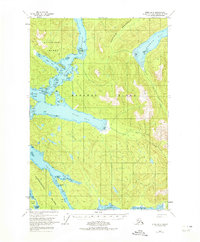
1948 Map of Sitka B-5
USGS Topo · Published 1974About this map
Peril Strait and the intricate channels surrounding Baranof Island dominate this coastal survey, where the maritime geography of Southeast Alaska is recorded through photogrammetric methods. The map details the complex navigation through Sergius Narrows and Kakul Narrows, essential corridors for travel between Sitka and the northern waters of the Alexander Archipelago. Evidence of human activity is found at the Highwater Cabin near St John Baptist Bay and further Cabins along the southeastern shoreline. The landscape is characterized by extensive Tidal Flats at the head of Fish Bay and Rodman Bay, while a Hot Spring is located inland along a tributary of Rodman Creek. This 1948 topography provides a baseline for understanding the wilderness and seasonal outposts within the Tongass National Forest before more modern developments reached these shores.
Find a feature on this map
61 named features on this map. Tap any name to fly to it.
Don’t see what you’re looking for? This feature index may not catch every label — zoom into the map to look around manually.
Map Details
Editions of this 1948 Sitka B-5 Map
3 editions found
Other maps of this area

1948 · Sitka A-5
USGS Topo · 1:63,360

1948 · Sitka C-6
USGS Topo · 1:63,360

1948 · Sitka B-5
USGS Topo · 1:63,360

1951 · Sitka B-4
USGS Topo · 1:63,360

1951 · Sitka C-5
USGS Topo · 1:63,360

1951 · Sitka A-6
USGS Topo · 1:63,360

1951 · Sitka B-6
USGS Topo · 1:63,360

1951 · Sitka C-4
USGS Topo · 1:63,360

1951 · Sitka B-5
USGS Topo · 1:63,360

1951 · Sitka
USGS Topo · 1:250,000