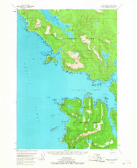
1951 Map of Sitka B-6
USGS Topo · Published 1967About this map
The maritime wilderness of the Tongass National Forest dominates this mid-century survey, centered on the complex waterways where the Pacific Ocean meets the Alexander Archipelago. The landscape is defined by the massive landmasses of Chichagof Island and Kruzof Island, separated by the broad expanse of Salisbury Sound. This mapping captures the intricate coastline of the Khaz Peninsula and the sheltered waters of Slocum Arm, providing an essential view of the region before modern development. Notable landmarks such as Cape Georgiana and Mt Georgiana serve as vital navigational markers for the seafaring routes between Neva Strait and Sukoi Inlet. Sparse human presence is indicated only by a few Cabins and a lone Cabin near Lake Suloia, emphasizing the isolation of these coastal reaches during the early 1950s.
Find a feature on this map
59 named features on this map. Tap any name to fly to it.
Don’t see what you’re looking for? This feature index may not catch every label — zoom into the map to look around manually.
Map Details
Editions of this 1951 Sitka B-6 Map
4 editions found
Other maps of this area

1948 · Sitka A-5
USGS Topo · 1:63,360

1948 · Sitka C-7
USGS Topo · 1:63,360

1948 · Sitka C-6
USGS Topo · 1:63,360

1948 · Sitka B-5
USGS Topo · 1:63,360

1951 · Sitka C-5
USGS Topo · 1:63,360

1951 · Sitka A-6
USGS Topo · 1:63,360

1951 · Sitka B-6
USGS Topo · 1:63,360

1951 · Sitka B-5
USGS Topo · 1:63,360

1951 · Sitka
USGS Topo · 1:250,000

1951 · Sitka C-6
USGS Topo · 1:63,360