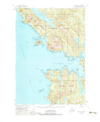
1951 Map of Sitka B-6
USGS Topo · Published 1983About this map
Chichagof Island and Kruzof Island dominate this coastal survey, separated by the wide waters of Salisbury Sound. The landscape is defined by intricate waterways and steep coastal topography, including the heights of Mt Georgiana and Khaz Peak. Human presence is minimal, noted primarily by a few Cabins tucked away near the shoreline, suggesting a period focused on maritime passage and seasonal habitation rather than permanent town sites.
Find a feature on this map
54 named features on this map. Tap any name to fly to it.
Don’t see what you’re looking for? This feature index may not catch every label — zoom into the map to look around manually.
Map Details
Editions of this 1951 Sitka B-6 Map
4 editions found
Other maps of this area

1948 · Sitka A-5
USGS Topo · 1:63,360

1948 · Sitka C-7
USGS Topo · 1:63,360

1948 · Sitka C-6
USGS Topo · 1:63,360

1948 · Sitka B-5
USGS Topo · 1:63,360

1951 · Sitka C-5
USGS Topo · 1:63,360

1951 · Sitka A-6
USGS Topo · 1:63,360

1951 · Sitka B-6
USGS Topo · 1:63,360

1951 · Sitka B-5
USGS Topo · 1:63,360

1951 · Sitka
USGS Topo · 1:250,000

1951 · Sitka C-6
USGS Topo · 1:63,360