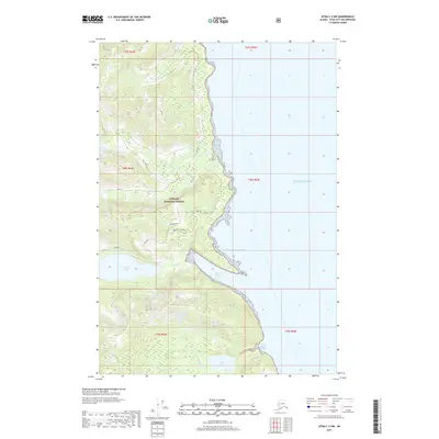
2017 Map of Sitka C-3 NW
USGS Topo · Published 2017About this map
Tongass National Forest dominates this coastal landscape, where the Chichagof Island interior meets the Gulf of Alaska. The map reveals a network of waterways and elevated viewpoints, most notably at Chatham View, overlooking the complex shoreline. To the south, Basket Lake feeds into Basket Cr, which eventually empties into the sheltered waters of Basket Bay. This 2017 survey reflects a largely untouched wilderness managed for conservation, though human presence is traced through isolated infrastructure like Trap Bay 5 Road. Further north, Kook Lake and its corresponding Kook Cr drain toward the coast, illustrating the typical high-latitude drainage patterns of Southeast Alaska. The eastern margin of the sheet opens into the Pacific Ocean, framing the mouth of Little Basket Bay and the jagged maritime boundary of the Sitka City and Borough.
Find a feature on this map
17 named features on this map. Tap any name to fly to it.
Don’t see what you’re looking for? This feature index may not catch every label — zoom into the map to look around manually.
Map Details
Editions of this 2017 Sitka C-3 NW Map
This is the sole edition of this map. No revisions or reprints were ever made.
Other maps of this area

1948 · Sitka C-3
USGS Topo · 1:63,360

1948 · Sitka D-3
USGS Topo · 1:63,360

1948 · Sitka D-4
USGS Topo · 1:63,360

1951 · Sitka C-4
USGS Topo · 1:63,360

1951 · Sitka
USGS Topo · 1:250,000

1951 · Sitka D-3
USGS Topo · 1:63,360

1951 · Sitka C-3
USGS Topo · 1:63,360

1952 · Sitka
USGS Topo · 1:250,000

1955 · Sitka D-4
USGS Topo · 1:63,360

1964 · Sitka
USGS Topo · 1:250,000