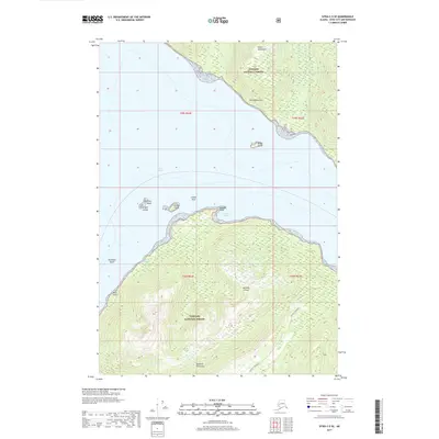
2017 Map of Sitka C-5 SE
USGS Topo · Published 2017About this map
Peril Strait serves as the central waterway between two of Alaska's most significant islands, Chichagof Island to the north and Baranof Island to the south. This coastal landscape is dominated by the heavily timbered terrain of the Tongass National Forest, which covers the Moore Mountains and the rising ground of the Duffield Peninsula. Maritime navigation features prominently along the complex shoreline, where sailors utilized Favorite Anchorage and passed landmarks such as Nismeni Point and the Cozian Reef. Numerous small landmasses dot the passage, including the Krugloi Islands, Elovoi Island, and Broad Island. The map illustrates a largely roadless wilderness where the relationship between the steep, forested slopes and the deep saltwater channels defines the local geography.
Find a feature on this map
21 named features on this map. Tap any name to fly to it.
Don’t see what you’re looking for? This feature index may not catch every label — zoom into the map to look around manually.
Map Details
Editions of this 2017 Sitka C-5 SE Map
This is the sole edition of this map. No revisions or reprints were ever made.
Other maps of this area

1948 · Sitka B-5
USGS Topo · 1:63,360

1951 · Sitka B-4
USGS Topo · 1:63,360

1951 · Sitka C-5
USGS Topo · 1:63,360

1951 · Sitka C-4
USGS Topo · 1:63,360

1951 · Sitka B-5
USGS Topo · 1:63,360

1951 · Sitka
USGS Topo · 1:250,000

1952 · Sitka
USGS Topo · 1:250,000

1964 · Sitka
USGS Topo · 1:250,000
1996 · Sitka B-5
USGS Topo · 1:63,360
2017 · Sitka C-5 NW
USGS Topo · 1:25,000