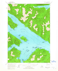
1951 Map of Sitka C-5
USGS Topo · Published 1965About this map
Tongass National Forest encompasses this coastal Alaskan landscape, where the waters of Hoonah Sound and Peril Strait meet between major islands. The map highlights the maritime geography of the early 1950s, detailing a labyrinth of passages such as Deadman Reach and sheltered spots like Favorite Anchorage. On the northern shore of Baranof Island, the survey identifies scattered Cabins, suggesting small-scale human presence amidst the dense forest and high peaks of Chichagof Island.
Find a feature on this map
43 named features on this map. Tap any name to fly to it.
Don’t see what you’re looking for? This feature index may not catch every label — zoom into the map to look around manually.
Map Details
Editions of this 1951 Sitka C-5 Map
4 editions found
Other maps of this area

1948 · Sitka D-5
USGS Topo · 1:63,360

1948 · Sitka D-4
USGS Topo · 1:63,360

1948 · Sitka C-6
USGS Topo · 1:63,360

1948 · Sitka D-6
USGS Topo · 1:63,360

1948 · Sitka B-5
USGS Topo · 1:63,360

1951 · Sitka B-4
USGS Topo · 1:63,360

1951 · Sitka C-5
USGS Topo · 1:63,360

1951 · Sitka B-6
USGS Topo · 1:63,360

1951 · Sitka C-4
USGS Topo · 1:63,360

1951 · Sitka B-5
USGS Topo · 1:63,360