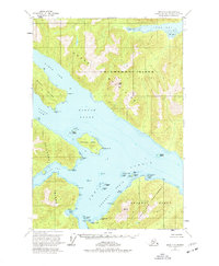
1951 Map of Sitka C-5
USGS Topo · Published 1977About this map
Chichagof Island and Baranof Island meet at the complex waterway of Peril Strait, a landscape defined by deep fjords and maritime navigation points. This 1951 survey, based on 1948 aerial photography, details the intricate coastline of Hoonah Sound and Ushk Bay. The map highlights several strategic maritime locations, including Favorite Anchorage and the Pogibshi Anchorage NE Base, which were essential for vessels navigating the passage between the islands. Terrain features such as the Moore Mountains and Finger Mtn dominate the interior, while the coastal areas are punctuated by landforms like Emmons Island and the Duffield Peninsula. This survey captures the region within the Tongass National Forest before significant modern development, showing the area as a purely maritime and wilderness environment.
Find a feature on this map
45 named features on this map. Tap any name to fly to it.
Don’t see what you’re looking for? This feature index may not catch every label — zoom into the map to look around manually.
Map Details
Editions of this 1951 Sitka C-5 Map
4 editions found
Other maps of this area

1948 · Sitka D-5
USGS Topo · 1:63,360

1948 · Sitka D-4
USGS Topo · 1:63,360

1948 · Sitka C-6
USGS Topo · 1:63,360

1948 · Sitka D-6
USGS Topo · 1:63,360

1948 · Sitka B-5
USGS Topo · 1:63,360

1951 · Sitka B-4
USGS Topo · 1:63,360

1951 · Sitka C-5
USGS Topo · 1:63,360

1951 · Sitka B-6
USGS Topo · 1:63,360

1951 · Sitka C-4
USGS Topo · 1:63,360

1951 · Sitka B-5
USGS Topo · 1:63,360