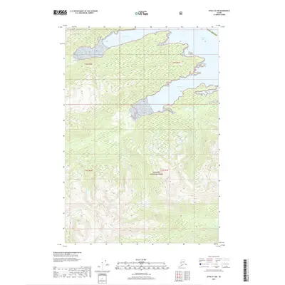
2017 Map of Sitka D-5 SW
USGS Topo · Published 2017About this map
Tongass National Forest dominates this coastal landscape on the eastern shore of Chichagof Island, where steep mountainous terrain meets the labyrinthine waterways of the Alexander Archipelago. The survey illustrates a wilderness defined by sharp elevation changes and intricate shorelines, particularly along the southern reaches of Tenakee Inlet. These glacial-carved waters extend into the land, creating sheltered harbors at Seal Bay and Long Bay. Located within the Sitka Borough, the area remains largely roadless, emphasizing the maritime character of Southeast Alaska's rainforest environment. The map captures the complex drainage patterns and dense contouring of the Tongass, showing how the topographical features dictate the natural corridors of this maritime forest.
Find a feature on this map
5 named features on this map. Tap any name to fly to it.
Don’t see what you’re looking for? This feature index may not catch every label — zoom into the map to look around manually.
Map Details
Editions of this 2017 Sitka D-5 SW Map
This is the sole edition of this map. No revisions or reprints were ever made.
Other maps of this area

1948 · Sitka D-5
USGS Topo · 1:63,360

1948 · Sitka C-6
USGS Topo · 1:63,360

1948 · Sitka D-6
USGS Topo · 1:63,360

1951 · Sitka C-5
USGS Topo · 1:63,360

1951 · Sitka
USGS Topo · 1:250,000

1951 · Sitka C-6
USGS Topo · 1:63,360

1951 · Sitka D-6
USGS Topo · 1:63,360

1951 · Sitka D-5
USGS Topo · 1:63,360

1952 · Sitka
USGS Topo · 1:250,000

1964 · Sitka
USGS Topo · 1:250,000