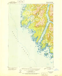
1950 Map of Sitka D-8
USGS Topo · Published 1950About this map
White Sulphur Springs sits at the coastal edge of this remote Alaskan wilderness, a region dominated by the maritime corridor of Lisianski Strait. Established within the Tongass National Forest, the map details the intricate coastlines of Yakobi Island and Chichagof Island, where numerous inlets like Squid Bay and Stag Bay carve into the mountainous interior. To the north, the Bohemia Basin and its namesake Bohemia Cr suggest early mineral interests or exploration in this glaciated terrain. The 1950 survey, based on 1948 aerial photography, provides an essential record of the natural topography before modern development, marking significant landmarks such as Takanis Peak and the sheltered waters of Surge Bay on the Pacific's edge.
Find a feature on this map
37 named features on this map. Tap any name to fly to it.
Don’t see what you’re looking for? This feature index may not catch every label — zoom into the map to look around manually.
Map Details
Editions of this 1950 Sitka D-8 Map
2 editions found
Other maps of this area

1948 · Sitka C-7
USGS Topo · 1:63,360

1948 · Mount Fairweather A-2
USGS Topo · 1:63,360

1948 · Sitka D-8
USGS Topo · 1:63,360

1948 · Mount Fairweather A-1
USGS Topo · 1:63,360

1950 · Sitka D-8
USGS Topo · 1:63,360

1951 · Sitka D-7
USGS Topo · 1:63,360

1951 · Mt Fairweather
USGS Topo · 1:250,000

1951 · Sitka
USGS Topo · 1:250,000

1951 · Sitka C-7
USGS Topo · 1:63,360

1952 · Sitka
USGS Topo · 1:250,000