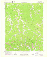
1971 Map of Sitka
USGS Topo · Published 1979About this map
Stambaugh and Sitka anchor the southern valleys of this Kentucky landscape, which is defined by the extensive extraction of coal and natural gas. The map documents an industrial geography where numerous Mines and Strip Mines are interspersed with rural communities such as Chandlerville and Davisville. The topography is a dense network of steep ridges and winding watercourses, including Hood Creek and Georges Creek, where small settlements and family cemeteries are tucked into narrow hollows. Religious and civic life is centered at local landmarks like Enterprise Ch and Tarkiln Ch. Revisions from the 1970s, shown in purple, highlight evolving infrastructure such as a prominent Pipeline and shifts in mining activity. This detailed record of the Lawrence and Johnson County line offers researchers a look at the relationship between the Appalachian terrain and the extractive economies that shaped its development during the mid-20th century.
Find a feature on this map
68 named features on this map. Tap any name to fly to it.
Don’t see what you’re looking for? This feature index may not catch every label — zoom into the map to look around manually.
Map Details
Editions of this 1971 Sitka Map
2 editions found
Other maps of this area

1886 · Prestonsburg
USGS Topo · 1:125,000

1892 · Prestonsburg
USGS Topo · 1:125,000

1903 · Kenova
USGS Topo · 1:125,000

1904 · Kenova
USGS Topo · 1:125,000

1911 · Louisa
USGS Topo · 1:48,000

1913 · Louisa
USGS Topo · 1:62,500

1914 · Inez
USGS Topo · 1:48,000

1915 · Paintsville
USGS Topo · 1:48,000

1916 · Inez
USGS Topo · 1:62,500

1917 · Paintsville
USGS Topo · 1:62,500