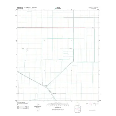
2012 Map of Sixmile Bend
USGS Topo · Published 2012About this map
Sixmile Bend and Ninemile Bend anchor this agricultural landscape in the Everglades region of Palm Beach County. The map reveals an intensive network of water management and irrigation infrastructure, dominated by the diagonal course of the Hillsboro Canal and the strictly horizontal reach of the Ocean Canal and E Canal St S. This geometry of drainage and transportation defines the local economy, with large-scale agricultural blocks partitioned by a grid of specialized roads. Named thoroughfares like Browns Farm Rd, Timco Farm Rd, and Vandecraft William Rd reflect the area's history of land ownership and farming operations. The lack of traditional town centers highlights the specialized industrial-agricultural nature of this part of Florida, where settlements like Sixmile Bend serve as functional nodes along the canals and highways such as Hatton Hwy.
Find a feature on this map
13 named features on this map. Tap any name to fly to it.
Don’t see what you’re looking for? This feature index may not catch every label — zoom into the map to look around manually.
Map Details
Editions of this 2012 Sixmile Bend Map
This is the sole edition of this map. No revisions or reprints were ever made.
Other maps of this area

1956 · West Palm Beach
USGS Topo · 1:250,000

1957 · West Palm Beach
USGS Topo · 1:250,000

1958 · West Palm Beach
USGS Topo · 1:250,000

1970 · Belle Glade
USGS Topo · 1:24,000

1970 · West Palm Beach 2 SW
USGS Topo · 1:24,000

1970 · Okeelanta
USGS Topo · 1:24,000

1970 · Loxahatchee NW
USGS Topo · 1:24,000

1970 · Loxahatchee SW
USGS Topo · 1:24,000

1970 · Pahokee
USGS Topo · 1:24,000

1970 · Shawano
USGS Topo · 1:24,000