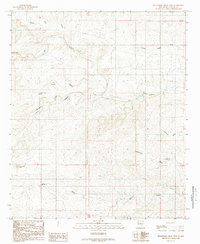
1989 Map of Sixteenmile Draw West
USGS Topo · Published 1989About this map
Rio Peñasco meanders through this portion of Chaves County, defining a landscape carved by seasonal watercourses and complex canyon systems. The terrain is dominated by the deeply incised Little Cuevo Canyon and the broad drainage of Charley White Draw, reflecting the arid environment of southeastern New Mexico. These geographical features illustrate the natural drainage patterns that have historically dictated ranching and land use in the region. Near the northern edge of the sheet, Singer Lake provides a rare point of surface water, serving as a vital landmark in an otherwise dry, rugged upland. This 1989 provisional edition, based on earlier aerial photography and field checks, captures the topographic character of the Chaves County high plains before modern infrastructure significantly altered the traditional landscape.
Find a feature on this map
4 named features on this map. Tap any name to fly to it.
Don’t see what you’re looking for? This feature index may not catch every label — zoom into the map to look around manually.
Map Details
Editions of this 1989 Sixteenmile Draw West Map
This is the sole edition of this map. No revisions or reprints were ever made.
Other maps of this area

1954 · Carlsbad
USGS Topo · 1:250,000

1958 · Carlsbad
USGS Topo · 1:250,000

1960 · Teel Ranch
USGS Topo · 1:62,500

1962 · Dunken
USGS Topo · 1:62,500

1965 · Lewis Peak NE
USGS Topo · 1:24,000

1978 · Encino Draw
USGS Topo · 1:24,000

1978 · Artesia
USGS Topo · 1:100,000
1978 · Holt Tank
USGS Topo · 1:24,000

1979 · Alamogordo
USGS Topo · 1:100,000
1989 · Singer Lake
USGS Topo · 1:24,000