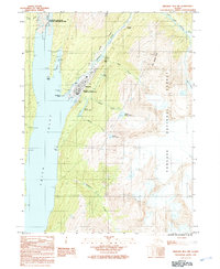
1991 Map of Skagway B-1 NW
USGS Topo · Published 1991About this map
Skagway serves as the focal point of this 1991 provisional survey, situated where the Skagway River meets the head of Taiya Inlet. The town's gold rush legacy is physically anchored by the Gold Rush Cemetery and preserved within the Klondike Gold Rush National Historical Park. The mapping captures the vital transportation corridors that shaped the region, from the historic White Pass and Yukon Railway to the modern Klondike Highway.
Find a feature on this map
38 named features on this map. Tap any name to fly to it.
Don’t see what you’re looking for? This feature index may not catch every label — zoom into the map to look around manually.
Map Details
Editions of this 1991 Skagway B-1 NW Map
This is the sole edition of this map. No revisions or reprints were ever made.
Other maps of this area

1948 · Skagway C-2
USGS Topo · 1:63,360

1948 · Skagway C-1
USGS Topo · 1:63,360

1949 · Skagway B-1
USGS Topo · 1:63,360

1951 · Skagway C-1
USGS Topo · 1:63,360

1951 · Skagway B-1
USGS Topo · 1:63,360

1951 · Skagway C-2
USGS Topo · 1:63,360

1952 · Skagway
USGS Topo · 1:250,000

1954 · Skagway B-2
USGS Topo · 1:63,360

1961 · Skagway
USGS Topo · 1:250,000
1991 · Skagway C-1 SW
USGS Topo · 1:25,000