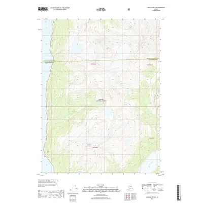
2017 Map of Skagway B-1 SW
USGS Topo · Published 2017About this map
Tongass National Forest dominates this coastal Alaskan landscape, where the high peaks of the Coast Mountains meet the deep waters of Taiya Inlet. The terrain is defined by extreme vertical relief, rising from the shoreline at Low Point to the prominent summit of Mt Villard. This 2017 survey captures the hydrology of the glacial wilderness, showing the course of the Katzehin River in the southeast and the remote Paradise Lake tucked into a high basin. The map also delineates the political boundary between Skagway Municipality and Haines Borough, which cuts across the steep drainage of Kasidaya Cr. This area is characterized by short, steep coastal streams like Dayehas Cr that drop rapidly from alpine heights to the sea, reflecting the classic fjord topography of Southeast Alaska.
Find a feature on this map
13 named features on this map. Tap any name to fly to it.
Don’t see what you’re looking for? This feature index may not catch every label — zoom into the map to look around manually.
Map Details
Editions of this 2017 Skagway B-1 SW Map
This is the sole edition of this map. No revisions or reprints were ever made.
Other maps of this area

1948 · Skagway A-1
USGS Topo · 1:63,360

1949 · Skagway B-1
USGS Topo · 1:63,360

1951 · Skagway A-1
USGS Topo · 1:63,360

1951 · Skagway B-1
USGS Topo · 1:63,360

1952 · Skagway
USGS Topo · 1:250,000

1954 · Skagway B-2
USGS Topo · 1:63,360

1954 · Skagway A-2
USGS Topo · 1:63,360

1961 · Skagway
USGS Topo · 1:250,000
1991 · Skagway A-1 NW
USGS Topo · 1:25,000
1991 · Skagway B-2 SE
USGS Topo · 1:25,000