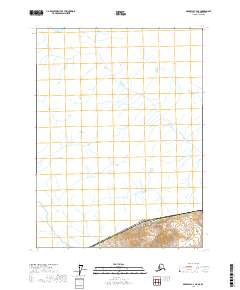
2017 Map of Skagway C-4 NE
USGS Topo · Published 2017About this map
Mt Ashmun rises as the primary topographic landmark on this international boundary sheet, where the rugged interior of the Haines Borough meets the territorial line of the United States and Canada. This 2017 survey documents a high-latitude wilderness defined by glacial drainages and extreme vertical relief, largely untouched by permanent settlement or infrastructure. The cartography focuses on the complex drainage patterns and contour elevations of the boundary peaks, including the high ridges of t26s r54e and t26s r55e. It captures a transition zone where the administrative boundary of the Alaska Haines Borough interacts with the international border, providing a precise record of the remote terrain before environmental shifts further alter the northern landscape.
Find a feature on this map
6 named features on this map. Tap any name to fly to it.
Don’t see what you’re looking for? This feature index may not catch every label — zoom into the map to look around manually.
Map Details
Editions of this 2017 Skagway C-4 NE Map
This is the sole edition of this map. No revisions or reprints were ever made.
Other maps of this area

1948 · Skagway C-4
USGS Topo · 1:63,360

1948 · Skagway C-3
USGS Topo · 1:63,360

1952 · Skagway
USGS Topo · 1:250,000
1954 · Skagway C-4
USGS Topo · 1:63,360
1954 · Skagway C-3
USGS Topo · 1:63,360

1961 · Skagway
USGS Topo · 1:250,000
2017 · Skagway C-4 SE
USGS Topo · 1:25,000
2017 · Skagway C-3 NW
USGS Topo · 1:25,000
2017 · Skagway C-4 SW
USGS Topo · 1:25,000
2017 · Skagway C-3 SW
USGS Topo · 1:25,000