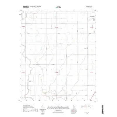
2020 Map of Skene
USGS Topo · Published 2020About this map
Cleveland and the surrounding agricultural landscapes of Bolivar County define this 2020 survey. The terrain is a complex network of wetlands and drainage systems, where Bogue Phalia and its many offshoots like Bogue Hasty and Pecan Bayou wind through the flat Mississippi Delta. Small rural settlements like Skene and Litton are connected by a grid of farm-to-market roads, such as Dummy Line Rd and Bond-Busby Rd, reflecting the region's enduring plantation and farming heritage. Genealogists and local historians can find points of interest like the Mount Zion Cem tucked away near the banks of the Bogue Phalia. Notable natural features such as Grassy Lake and Sandy Slough provide insight into the original hydraulic character of the basin before modern land management, while the expansion of Cleveland near Yale Ests shows the modern suburban footprint on the edge of the historic cotton country.
Find a feature on this map
52 named features on this map. Tap any name to fly to it.
Don’t see what you’re looking for? This feature index may not catch every label — zoom into the map to look around manually.
Map Details
Editions of this 2020 Skene Map
This is the sole edition of this map. No revisions or reprints were ever made.
Other maps of this area

1931 · Drew
USGS Topo · 1:48,000

1934 · Cleveland
USGS Topo · 1:62,500

1935 · Mound Bayou
USGS Topo · 1:62,500

1939 · Pace
USGS Topo · 1:62,500

1939 · Choctaw
USGS Topo · 1:62,500

1940 · Cleveland
USGS Topo · 1:62,500

1953 · Greenwood
USGS Topo · 1:250,000

1956 · Greenwood
USGS Topo · 1:250,000
1966 · Merigold
USGS Topo · 1:24,000

1966 · Cleveland
USGS Topo · 1:24,000