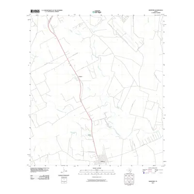
2010 Map of Skidmore
USGS Topo · Published 2010About this map
Skidmore anchors this 2010 survey of Bee County, where the grid-like streets of the town give way to the expansive South Texas ranching and agricultural landscape. The transportation corridor follows the path of U.S. HWY 181 Bus and Old Hwy 181, which connect the main settlement with the smaller locality of Yougeen to the northwest. This area is defined by its complex drainage network, where Poesta Creek and Aransas Creek converge toward the Aransas River, shaping the layout of local roads and property boundaries. Genealogists and local historians will find Evergreen Cemetery situated between the two settlements along the highway. The map reflects a landscape where rural life is organized around these essential waterways and historical transport routes, including corridors like FM 797 and FM 888.
Find a feature on this map
27 named features on this map. Tap any name to fly to it.
Don’t see what you’re looking for? This feature index may not catch every label — zoom into the map to look around manually.
Map Details
Editions of this 2010 Skidmore Map
This is the sole edition of this map. No revisions or reprints were ever made.
Other maps of this area

1927 · Mathis
USGS Topo · 1:62,500

1953 · Beeville
USGS Topo · 1:250,000

1954 · Skidmore
USGS Topo · 1:62,500

1954 · Fleming
USGS Topo · 1:62,500

1954 · Mathis
USGS Topo · 1:62,500

1954 · Sinton
USGS Topo · 1:62,500

1956 · Beeville
USGS Topo · 1:250,000

1960 · Beeville
USGS Topo · 1:250,000

1979 · Burkes Ridge
USGS Topo · 1:24,000
1979 · Tynan
USGS Topo · 1:24,000