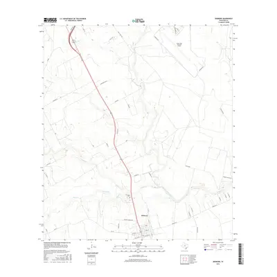
2016 Map of Skidmore
USGS Topo · Published 2016About this map
The settlement of Skidmore serves as the focal point for this Bee County study, positioned at the convergence of vital local transit routes including FM 797 and FM 888. The landscape is defined by the hydrologic network of the Aransas River and its numerous tributaries such as Poesta Cr and Olmos Creek. To the north, the Chase Field Industrial Airport stands as a significant contemporary landmark, surrounded by its namesake Perimeter Rd. Local history is anchored by the Evergreen Cem, located just north of the town center near the banks of Aransas Cr. The map captures a transition toward residential development in the east, evidenced by the presence of River Oaks and Hideaway Ranchette, which contrast with the larger agricultural parcels and rural roads like Old St Marys Rd and Guajolote Rd that lattice the surrounding territory.
Find a feature on this map
50 named features on this map. Tap any name to fly to it.
Don’t see what you’re looking for? This feature index may not catch every label — zoom into the map to look around manually.
Map Details
Editions of this 2016 Skidmore Map
This is the sole edition of this map. No revisions or reprints were ever made.
Other maps of this area

1927 · Mathis
USGS Topo · 1:62,500

1953 · Beeville
USGS Topo · 1:250,000

1954 · Skidmore
USGS Topo · 1:62,500

1954 · Fleming
USGS Topo · 1:62,500

1954 · Mathis
USGS Topo · 1:62,500

1954 · Sinton
USGS Topo · 1:62,500

1956 · Beeville
USGS Topo · 1:250,000

1960 · Beeville
USGS Topo · 1:250,000

1979 · Burkes Ridge
USGS Topo · 1:24,000
1979 · Tynan
USGS Topo · 1:24,000