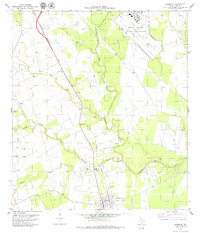
1979 Map of Skidmore
USGS Topo · Published 1979About this map
The Southern Pacific railroad corridor anchors this survey of Bee County, following a direct line through the settlement of Yougeen toward the town of Skidmore. This transportation spine is paralleled by the winding course of Poesta Creek, which eventually joins the Aransas River as it flows eastward. The landscape reflects a mix of agricultural utility and military presence, dominated in the northeast by the extensive grounds of the Chase Field Naval Air Station.
Find a feature on this map
21 named features on this map. Tap any name to fly to it.
Don’t see what you’re looking for? This feature index may not catch every label — zoom into the map to look around manually.
Map Details
Editions of this 1979 Skidmore Map
This is the sole edition of this map. No revisions or reprints were ever made.
Other maps of this area

1927 · Mathis
USGS Topo · 1:62,500

1953 · Beeville
USGS Topo · 1:250,000

1954 · Skidmore
USGS Topo · 1:62,500

1954 · Fleming
USGS Topo · 1:62,500

1954 · Mathis
USGS Topo · 1:62,500

1954 · Sinton
USGS Topo · 1:62,500

1956 · Beeville
USGS Topo · 1:250,000

1960 · Beeville
USGS Topo · 1:250,000

1979 · Burkes Ridge
USGS Topo · 1:24,000
1979 · Tynan
USGS Topo · 1:24,000