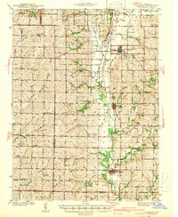
1942 Map of Skidmore
USGS Topo · Published 1942About this map
Burlington Junction and Skidmore anchor this agricultural region of northwest Missouri during the mid-twentieth century. The landscape is defined by the broad floodplain of the Nodaway River, which flows through the center of the sheet, supported by a dense network of tributaries including Muddy Creek, Hagey Creek, and Little Tarkio Creek. The region’s rural development is visible in the exceptional number of district schoolhouses, such as Hedge College Sch, Little Brick Sch, and Lone Star Sch, marking the grid-patterned townships of Lincoln, Green, and Monroe.
Find a feature on this map
66 named features on this map. Tap any name to fly to it.
Don’t see what you’re looking for? This feature index may not catch every label — zoom into the map to look around manually.
Map Details
Editions of this 1942 Skidmore Map
2 editions found

Other maps of this area

1920 · Craig
USGS Topo · 1:62,500

1926 · Maitland
USGS Topo · 1:62,500

1927 · Bolckow
USGS Topo · 1:62,500

1939 · Tarkio
USGS Topo · 1:62,500

1939 · Farragut
USGS Topo · 1:62,500

1939 · Skidmore
USGS Topo · 1:62,500

1940 · Tarkio
USGS Topo · 1:62,500

1940 · Farragut
USGS Topo · 1:62,500

1940 · Coin
USGS Topo · 1:62,500

1940 · New Market
USGS Topo · 1:62,500