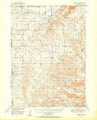
1950 Map of Skunk Lake
USGS Topo · Published 1950About this map
The Niobrara River winds across the northern landscape of this Sheridan and Box Butte County borderland, defining a region characterized by remote ranches and a high density of rural schoolhouses. The 1940s aerial surveys captured a network of one-room schools including School No 30, School No 93, and School No 65, which served the isolated farming families of the West Mirage and East Mirage districts. This map provides critical documentation for genealogists, showing family-named landmarks like Sandoz Ranch and Albrecht Lake alongside community burial grounds such as St Peters Cem and Neely Flat Cem. The southern half of the quadrangle is dominated by a complex system of alkaline depressions and wetlands, including Skunk Lake, Dillings Lake, and Goose Lake, illustrating the unique hydrology of the Nebraska Sandhills before modern center-pivot irrigation significantly altered the surface water patterns of the plains.
Find a feature on this map
22 named features on this map. Tap any name to fly to it.
Don’t see what you’re looking for? This feature index may not catch every label — zoom into the map to look around manually.
Map Details
Editions of this 1950 Skunk Lake Map
2 editions found

Other maps of this area

1946 · Berea Creek East
USGS Topo · 1:24,000

1947 · Box Butte NE
USGS Topo · 1:24,000

1947 · Box Butte
USGS Topo · 1:24,000

1948 · Berea Creek East
USGS Topo · 1:24,000

1948 · Antioch
USGS Topo · 1:62,500

1948 · Lakeside
USGS Topo · 1:62,500

1948 · Twin Lakes
USGS Topo · 1:62,500

1949 · Box Butte NE
USGS Topo · 1:24,000

1949 · Antioch
USGS Topo · 1:62,500

1949 · Box Butte
USGS Topo · 1:24,000