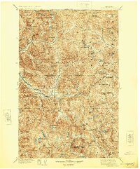
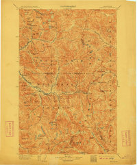
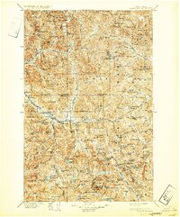
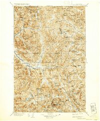
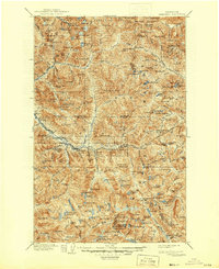
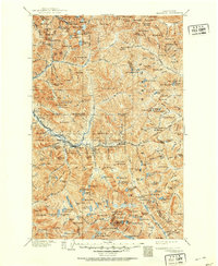
1905 Map of Skykomish
USGS Topo · Published 1924About this map
Monte Cristo and the high-alpine mining district around the South Fork Sauk River define this 1905 survey, documenting the region shortly after the initial silver and gold boom. The map illustrates a landscape shaped by industrial ambition, featuring the precarious routes to remote outposts like Mineral City and Galena. The central corridor is dominated by the Great Northern Railway, which follows the Tye River to the massive engineering feat of the Cascade Tunnel at Stevens Pass. Along this rail line, small settlements such as Skykomish, Scenic, and Berlin served as vital supply points. Within the Snoqualmie National Forest, the topography is characterized by high peaks like Baring Mtn and Del Campo Pk, alongside numerous alpine water bodies including Blanca Lake and Snoqualmie Lake.
Find a feature on this map
152 named features on this map. Tap any name to fly to it.
Don’t see what you’re looking for? This feature index may not catch every label — zoom into the map to look around manually.
Map Details
Editions of this 1905 Skykomish Map
7 editions found

Other maps of this area

1897 · Mount Stuart
USGS Topo · 1:125,000

1899 · Glacier Peak
USGS Topo · 1:125,000

1899 · Stillaguamish
USGS Topo · 1:125,000

1901 · Glacier Peak
USGS Topo · 1:125,000

1901 · Stilaguamish
USGS Topo · 1:125,000

1901 · Chiwaukum
USGS Topo · 1:125,000

1901 · Snoqualmie Pass
USGS Topo · 1:125,000

1902 · Skykomish
USGS Topo · 1:125,000

1902 · Mount Stuart
USGS Topo · 1:125,000

1902 · Stehekin
USGS Topo · 1:125,000